Map Of Middle Earth – Full Middle Earth Map
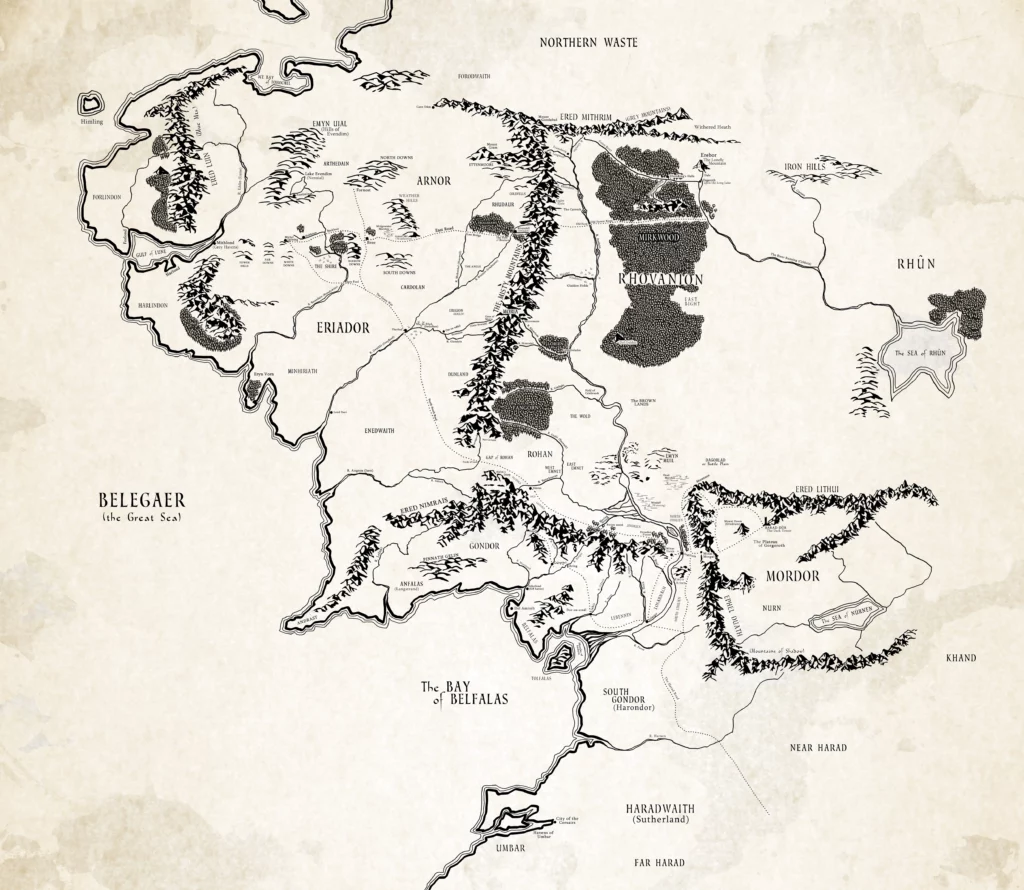
The map of Middle-earth is a fictional geographical depiction created by J.R.R. Tolkien for his fantasy world where the stories of “The Hobbit” and “The Lord of the Rings” take place. Middle-earth is part of Tolkien’s larger mythological world, known as Arda.
The map features various distinct regions, each with its own geography, cultures, and histories. Some of the notable regions and landmarks include:
- The Shire: The home of the Hobbits, known for its peaceful countryside.
- Rivendell: An Elven refuge, known for its beauty and wisdom.
- Mordor: A desolate, volcanic region, and the realm of the dark lord Sauron.
- Gondor: A major human kingdom, known for its fortresses and cities like Minas Tirith.
- Rohan: Another human kingdom, famous for its horse-lords and the city of Edoras.
- Fangorn Forest: An ancient forest, home to the Ents.
- Misty Mountains: A major mountain range, with significant locations like the Mines of Moria.
- Lothlórien: An Elven realm, characterized by its golden trees and the Lady Galadriel.
The map also includes numerous rivers, forests, seas, and other natural landmarks. It’s celebrated for its detailed and imaginative geography, contributing significantly to the depth and believability of Tolkien’s world.
The map of Middle-earth, as depicted in J.R.R. Tolkien’s “The Hobbit” and “The Lord of the Rings”, is an iconic and integral part of his fantasy world. Tolkien, a scholar with a deep interest in languages and mythology, created Middle-earth with an attention to detail that extends to its geography, cultures, and history. Here’s a more detailed overview:
Geographical Features
- Eriador: This large region in the northwest includes the Shire, Bree, and the ancient kingdom of Arnor.
- The Lonely Mountain (Erebor): A significant location in “The Hobbit”, known for its Dwarven kingdom and the dragon Smaug.
- The Grey Havens: A port city from where Elves depart to the Undying Lands.
Other Realms and Locations
- Isengard: Once a fortress of Gondor, later the domain of Saruman.
- The Woodland Realm: A kingdom of Silvan Elves in the northern part of Mirkwood forest.
- The Dead Marshes: A haunted marshland near Mordor, known for its ghostly lights and deadly environment.
- Helm’s Deep: A fortress in Rohan, the site of a major battle in “The Lord of the Rings”.
Natural Landmarks and Features
- Mount Doom (Orodruin): The volcano in Mordor where the One Ring was forged and eventually destroyed.
- The Great River Anduin: The longest river in Middle-earth, flowing from the Misty Mountains to the Sea of Rhûn.
- The Sea of Rhûn and Harad: Regions to the east and south of Middle-earth, less explored in the stories but integral to the world’s expansiveness.
Cultural and Historical Significance
- The map reflects not only the physical geography but also the cultural and political divisions within Middle-earth. Each region has its own distinct culture, language, and history.
- The map’s design and layout play a crucial role in the narrative of Tolkien’s stories, with characters’ journeys and the unfolding of events closely tied to the geography.
Tolkien’s Creation Process
- Tolkien’s background in philology and his interest in mythologies, particularly Norse and Celtic, influenced the creation of Middle-earth.
- He drew the original maps himself, ensuring that the geography was closely integrated with the plot and the lore of his world.
- The maps were also vital in giving readers a sense of scope and aiding in the visualization of the epic journeys undertaken by the characters.
The map of Middle-earth is not just a background element but a central component of Tolkien’s storytelling, adding depth and realism to the narrative. It has inspired countless adaptations, including detailed atlases, and remains a beloved aspect of his literary legacy.
Regional Analyses Of Middle-earth
let’s delve deeper into the regional analysis of Middle-earth:
- Eriador: This region is characterized by a mix of wilderness and settled areas. The Shire, home to the Hobbits, is a notable part of Eriador, known for its pastoral landscape and peaceful way of life. Bree, a rare example of a mixed settlement of Men and Hobbits, and Rivendell, an Elven haven led by Elrond, are also key locations in Eriador.
- The Misty Mountains: A significant barrier in Middle-earth, these mountains are home to various creatures and hold many secrets, including the ancient Dwarf-realm of Moria. The range plays a crucial role in several characters’ journeys, especially in “The Hobbit” and “The Lord of the Rings.”
- Rhovanion: This region includes the vast forest of Mirkwood, known for its dense woods and dark history, and Lothlórien, an Elven realm of great beauty. Fangorn Forest, where the Ents reside, and Isengard, the stronghold of Saruman, are also located here.
- Rohan and Gondor: Rohan, known for its horse-lords, is a key ally to Gondor, a major kingdom of Men. Gondor’s capital, Minas Tirith, is a focal point in the War of the Ring. The two regions are geographically and politically intertwined.
- Mordor: The land of the Dark Lord Sauron, Mordor is a desolate, volcanic territory, surrounded by mountain ranges. It houses Mount Doom, where the One Ring was forged, and Barad-dûr, Sauron’s fortress.
- Rhûn and the East: The Sea of Rhûn and surrounding areas represent the largely unexplored eastern part of Middle-earth. The Iron Hills and Erebor, the Lonely Mountain, are significant locations known for their Dwarf populations.
Each of these regions has its own distinct geography, culture, and role in the broader narrative of Middle-earth, offering a rich tapestry for exploration on your website.